Clean up continues following significant rain event
- Date:
- Feb 5, 2020
After two days of heavy rain, blue skies have offered a welcome reprieve in the Queenstown Lakes District. Clean up is underway with minor slips and surface flooding around the district.
Lakes Wānaka and Wakatipu have levelled off and are not expected to cause any issues. Water has receded dramatically overnight on the Glenorchy foreshore where water overtopped the Rees river bank at around 4.30pm, with some water damage to two properties. A small number of residents who self-evacuated were able to return to their properties first thing this morning.
A number of State Highways remain closed and QLDC recommends that people refer to the Waka Kotahi NZ Transport Agency website and social media channels for the latest updates on all State Highways. In particular, the NZTA highway (SH6) between Frankton and Kingston remains closed at the Kingston end but is expected to reopen this afternoon (NZTA will provide an update on this by 4.00pm today). Commercial water taxis have been operating to enable passage for visitors and locals. There may also be possible rock falls along the Kawarau Gorge section of SH6.
A number of local roads are also still affected:
- Fernhill to Sunshine Bay – the road is closed between Fernhill and Sunshine Bay due to a landslide. Contractors are clearing the site. Glenorchy Road is open via a detour, drivers are asked to follow the detour signs.
- Glenorchy Road is open - a slip that had closed the road near Bob's Cove has been partially cleared and the road is open to single lane traffic. Drivers are asked to please take care driving through this area.
- Paradise Road (Earnslaw Burn washout) - currently closed at Priory Road / Paradise Road turn off.
- Kinloch Road – closed on the Glenorchy side of the Dart River Bridge.
- Routeburn Road (Scott Creek washout) – road closed and not passable, contractors are responding.
- Mount Aspiring Road – closed from just after the Treble Cone ski field turn off onwards.
- Gibbston Back Road - Open but 4wd recommended. There is significant scouring on the road - please take care.
- Skippers Road – closed due to a slip at Gorilla Rock.
Engineers are continuing to assess any damage to the roading network and updates will be provided as and when roads reopen. Drivers are advised to slow down, stay alert and expect the unexpected while the roads are cleared and surface flooding subsides.
The rain event has also caused surface flooding on various reserves and affected various trails and tracks around the region, including the Kelvin Heights track which is currently closed. Please check before you head out via the Department of Conservation’s website and social media channels.
Further updates on local road closures and any other issues that arise will be provided on QLDC’s Facebook page (@QLDCinfo).
ENDS|KUA MUTU.
Media contact: communications@qldc.govt.nz or call 03 441 1802.
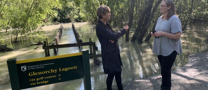
Pictured: QLDC General Manager Corporate Services (Local Controller) Meaghan Miller with Councillor Nikki Gladding near the flooded Glenorchy Lagoon where the Rees River overtopped the stop bank yesterday afternoon.